
St John's
Jolly
Harbour
Harbour
English Harbour
Cades Reef
Mamora
Bay
Bay
Carlisle
Bay
Bay
Google Maps
Nonsuch
Bay
Bay
Guiana
Island
Island
Long
Island
Island
For coastal chart overview click HERE

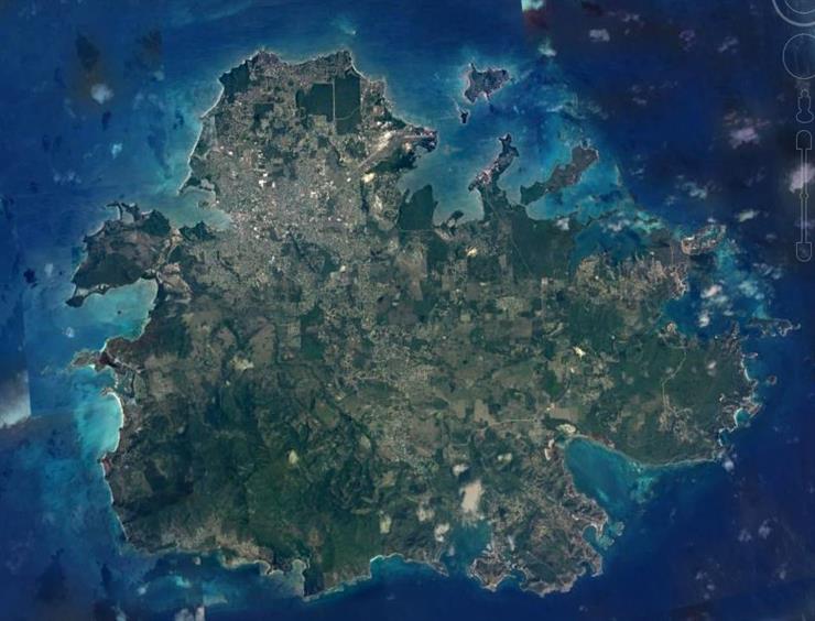
Antigua is a small island in the West Indies. It is one of the Leeward Islands in the Caribbean region and is the main island of the state of Antigua and Barbuda. It is approximately the size of the Isle of Wight (UK) at 281km2/ 108 sq mi.
Antigua sits on a plateau with Barbuda to its North, with Antigua sitting on the Southern edge, having a steep dropoff as close as 2km from the Southern shore (see Coastal Chart)
It has 3 main harbours: St John's (the capital) in the NorthWest, Jolly Harbour in the West and English Harbour/ Falmouth Harbour in the South East.
Inshore waters comprise of coral reefs, seagrass beds and sandy bays. Some bays are lined with mangroves and there are also brackish lagoons and ponds. There are no rivers in Antigua and freshwater ponds are few, but includes a resevoir (Potworks).
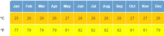
Average sea temperatures range frron 26oC (Feb/ Mar) to 29oC (Aug to Oct). Underwater visibility ranges from 7m to 25m. Tides are small, with a range of ~30cm.
Antigua sits on a plateau with Barbuda to its North, with Antigua sitting on the Southern edge, having a steep dropoff as close as 2km from the Southern shore (see Coastal Chart)
It has 3 main harbours: St John's (the capital) in the NorthWest, Jolly Harbour in the West and English Harbour/ Falmouth Harbour in the South East.
Inshore waters comprise of coral reefs, seagrass beds and sandy bays. Some bays are lined with mangroves and there are also brackish lagoons and ponds. There are no rivers in Antigua and freshwater ponds are few, but includes a resevoir (Potworks).
Average sea temperatures range frron 26oC (Feb/ Mar) to 29oC (Aug to Oct). Underwater visibility ranges from 7m to 25m. Tides are small, with a range of ~30cm.
Falmouth
Harbour
Harbour
Airport
Urlings
General:
Climate:
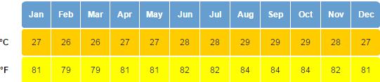
Average Air Temperature
Average Sea Temperature
Average
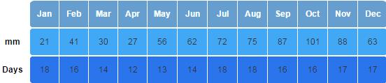
Rainfall
Rainfall